Bali’s landscape is shaped by volcanic mountains, deep river valleys, and steep ravines known locally as tukad. For centuries, these natural features separated villages, agricultural communities, and different regions of the island.
The history of Bali’s bridges reflects how communities gradually overcame these geographical barriers. What began with simple bamboo and timber crossings eventually developed into permanent masonry structures, modern concrete bridges, and major infrastructure projects supporting tourism, trade, and transportation.
From sacred river confluences to impressive engineering landmarks, Bali’s bridges tell an important story about the island’s development.
1. Ancient Ravines and Sacred River Confluences (Campuhan)
Before modern engineering, crossing Bali’s rivers was closely connected to local geography, community life, and spiritual traditions.
The Sacred Geography of Rivers
Bali’s rivers originate from volcanic landscapes, including the areas surrounding Mount Batur and Mount Agung. Over time, these waterways carved deep ravines across regions such as Gianyar, Badung, and Tabanan.
One particularly important geographical feature is the Campuhan, a place where two rivers meet. These confluences are traditionally regarded as spiritually significant locations where different energies come together.
A well-known example is the Campuhan in Ubud, where the Yeh Wos and Oos rivers meet. The area is associated with Gunung Lebah Temple, traditionally linked to the spiritual journey of Rsi Markandeya.
Traditional Footbridges
Before permanent bridges existed, Balinese villages relied on simple structures made from locally available materials.
Traditional crossings commonly used:
- Bamboo: Lightweight and flexible, making it suitable for small footbridges.
- Coconut tree trunks: Used as basic supports or narrow walking surfaces.
- Woven rattan: Helped secure and connect structural elements.
These crossings allowed villagers to travel between neighbouring communities, access agricultural land, and reach local markets.
However, temporary bridges were vulnerable to heavy rainfall and strong river currents during the monsoon season (musim hujan). Some communities therefore continued to rely on riverbed crossings when conditions allowed.
2. The Dutch Colonial Era: Masonry Bridges and Mountain Logistics
During the early 20th century, the expansion of colonial administration and transportation networks gradually transformed Bali’s infrastructure.
Traditional village pathways began connecting to more permanent road systems, creating greater demand for bridges that could support carts and early motor vehicles.
| Era / Feature | Structural Characteristics | Strategic Impact |
| Colonial masonry arches | Local volcanic stone, mortar, and heavy timber structures | Replaced some seasonal crossings with more permanent routes |
| North–south corridors | Roads engineered through Bedugul and the central highlands | Improved connections between northern and southern Bali |
| Heritage ravine bridges | Early concrete and steel truss structures | Supported regional transportation and connections between settlements |
These developments helped establish more reliable transportation routes between Singaraja, Denpasar, Tabanan, and other parts of the island.
They also supported the movement of agricultural products and strengthened connections between regional administrative centres and traditional royal compounds (puri).
3. Post-Independence Bali: Expansion of Civil Infrastructure
Following Indonesian independence in 1945, population growth, economic development, and increasing transportation needs created demand for stronger infrastructure.
Concrete construction and modern engineering techniques made it possible to build bridges across deeper valleys and more challenging landscapes.
One of the most notable examples is Jembatan Tukad Bangkung, located in Pelaga, Badung Regency.
Jembatan Tukad Bangkung: A Landmark of Modern Engineering
Jembatan Tukad Bangkung is one of Bali’s most impressive inland bridge structures, connecting communities across a deep mountain valley.
Key details include:
- Opening: December 2006.
- Length: Approximately 360 metres.
- Width: Approximately 9.6 metres.
- Pillar height: Up to 71.14 metres above the valley floor.
- Foundation depth: Approximately 41 metres.
The bridge was designed to provide a more direct transportation connection through the Pelaga highlands, reducing reliance on winding mountain roads.
Its elevated structure also allows the river valley below to remain largely unobstructed, making it an important example of modern bridge engineering in Bali.
Beyond its engineering significance, Jembatan Tukad Bangkung has improved regional accessibility and supports transportation between communities in the highlands and southern Bali.
4. Island Connections: Nusa Lembongan and Modern Maritime Bridges
Bali’s infrastructure development extends beyond the main island. As tourism and local communities expanded across nearby islands, bridges became important connections for everyday transportation and economic activity.
Two major examples are the Yellow Bridge between Nusa Lembongan and Nusa Ceningan and the Bali Mandara Toll Road across Benoa Bay.
The Yellow Bridge (Jembatan Cinta): Connecting Nusa Lembongan and Nusa Ceningan
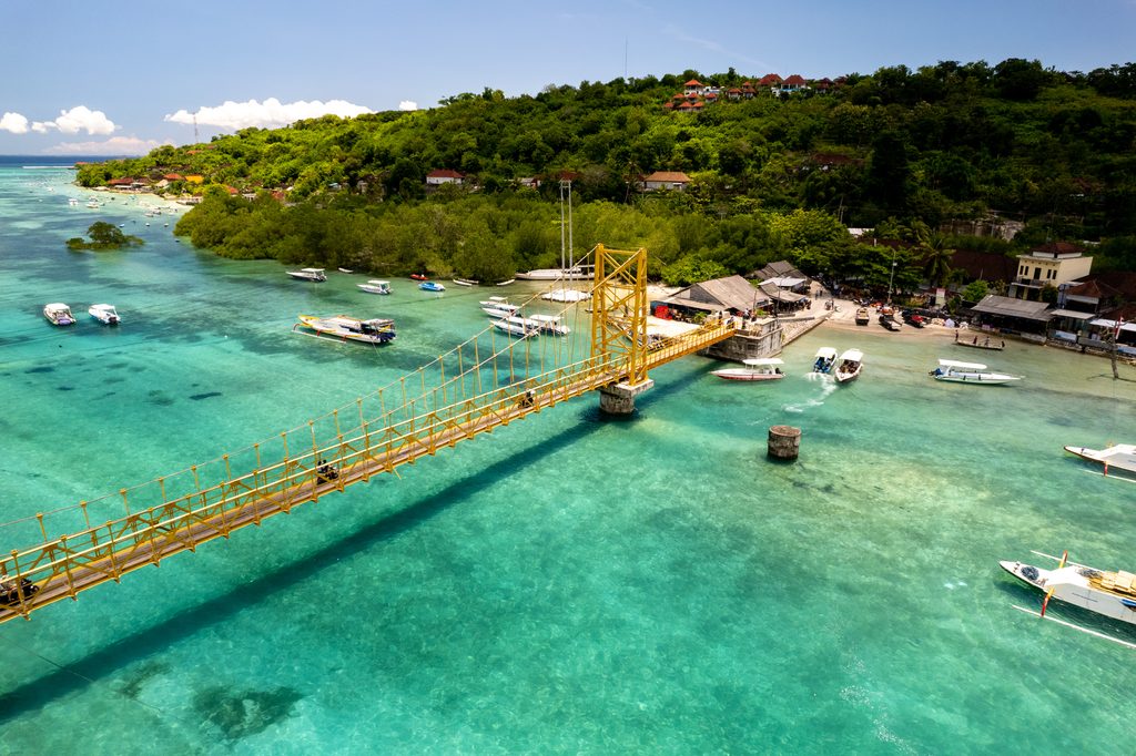
<escape>**</escape>The Yellow Bridge, also known as Jembatan Cinta or the Bridge of Love, connects Nusa Lembongan and Nusa Ceningan through a narrow marine channel.
The original bridge was reportedly constructed around 1995 as a narrow suspension crossing designed for pedestrians and light motorcycles.
However, on 16 October 2016, the original structure collapsed during a religious gathering. The incident highlighted the importance of structural capacity and safety for a bridge serving both residents and visitors.
Following reconstruction, the new bridge reopened in February 2017 with reinforced structural elements and improved foundations.
Today, the Yellow Bridge remains an essential connection between the two islands. It supports:
- Daily transportation for local residents.
- School journeys and community activities.
- The movement of supplies and goods.
- Tourism and local businesses.
Its distinctive yellow appearance has also made it one of the most recognisable landmarks in the Nusa Islands.
Bali Mandara Toll Road: A Modern Bridge Across Benoa Bay
The Bali Mandara Toll Road represents another major milestone in the island’s infrastructure development.
Officially inaugurated on 23 September 2013 by President Susilo Bambang Yudhoyono, the toll road was developed ahead of the APEC Summit held in Bali.
The project stretches approximately 12.7 kilometres across Benoa Bay, connecting Denpasar, Ngurah Rai International Airport, and Nusa Dua.
Its main engineering and transportation features include:
- An elevated roadway constructed over the sea using concrete supports.
- Dedicated motorcycle lanes.
- A connection between major tourism and transportation areas.
- Wind-monitoring equipment to support operational safety.
Built in approximately 14 months, the Bali Mandara Toll Road significantly improved travel connections around southern Bali.
It also became a prominent example of large-scale infrastructure designed to support tourism, international events, and regional mobility.
Timeline of Bali’s Infrastructure Milestones
The following timeline highlights several important stages in the development of Bali’s bridges.
| Period / Year | Infrastructure Milestone | Historical Significance |
| Pre-20th century | Traditional bamboo and timber crossings | Villages relied on locally built footbridges across rivers and ravines |
| 1900s–1930s | Colonial-era masonry and truss bridges | More permanent transportation routes developed through the island’s highlands |
| Around 1995 | Construction of the original Yellow Bridge | Established an important connection between Nusa Lembongan and Nusa Ceningan |
| December 2006 | Opening of Jembatan Tukad Bangkung | Created a major highland connection across a deep river valley |
| September 2013 | Inauguration of Bali Mandara Toll Road | Improved transportation between Denpasar, the airport, and Nusa Dua |
| October 2016 | Collapse of the original Yellow Bridge | Highlighted the need for improved structural safety |
| February 2017 | Reopening of the rebuilt Yellow Bridge | Restored an essential connection between the two islands |
Frequently Asked Questions About Bridges in Bali
What is the longest bridge in Bali?
The Bali Mandara Toll Road is the longest major bridge and elevated roadway structure in Bali, extending approximately 12.7 kilometres across Benoa Bay.
For inland bridges crossing river valleys, Jembatan Tukad Bangkung is a major landmark, measuring approximately 360 metres in length.
What is the highest bridge in Bali?
Jembatan Tukad Bangkung in Pelaga, Badung Regency, is among Bali’s highest inland bridges. Its supporting pillars reach approximately 71.14 metres above the valley floor.
Why is the bridge between Nusa Lembongan and Nusa Ceningan called the Yellow Bridge?
The bridge is named after its distinctive yellow-painted structure, which makes it easy to recognise across the narrow channel between the islands.
It is also known as Jembatan Cinta, meaning Bridge of Love, and has become a popular landmark for residents and visitors.
When did the Yellow Bridge collapse, and when was it rebuilt?
The original Yellow Bridge collapsed on 16 October 2016 during a religious gathering. Following reconstruction, the replacement bridge reopened in February 2017, restoring the connection between Nusa Lembongan and Nusa Ceningan.
How do modern bridges in Bali withstand earthquake risks?
Bali is located in a seismically active region, making earthquake resistance an important consideration in modern infrastructure projects.
Bridge engineers use structural design measures such as deep foundations, reinforced concrete, and specialised support systems to improve stability and accommodate ground movement.
The specific engineering methods depend on the bridge’s location, geological conditions, and structural requirements.
What is the spiritual significance of river confluences (Campuhan) in Bali?
In Balinese Hindu traditions, a Campuhan is the meeting point of two or more rivers and is often regarded as a spiritually significant place.
These locations are associated with purification and the meeting of different natural energies. Some river confluences are also connected to nearby temples and traditional religious ceremonies.
Final Thoughts
The history of Bali’s bridges is a story of how communities have adapted to the island’s challenging geography while maintaining their cultural identity.
What began with simple bamboo and timber crossings has evolved into permanent masonry structures, elevated concrete bridges, and major transportation infrastructure.
From Jembatan Tukad Bangkung, which connects communities across the highlands, to the Yellow Bridge, which links Nusa Lembongan and Nusa Ceningan, these structures play an important role in everyday life.
The Bali Mandara Toll Road further demonstrates how modern engineering has helped improve accessibility, support tourism, and connect important destinations across southern Bali.
Together, these bridges represent more than transportation infrastructure. They reflect Bali’s journey from isolated river valleys and traditional communities towards a more connected island, where modern development continues alongside its distinctive cultural and spiritual heritage.